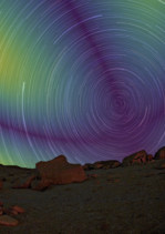
Can you tell which way is north just by looking at the daytime sky, without using a compass or GPS or even knowing the position of the Sun? Thanks to a new optical method, the answer could soon be â€Å�yesâ€Â. Developed by researchers at Aix-Marseille University in France, the method works by analysing the polarization patterns in scattered daylight. As well as aiding the development of alternative navigation techniques, it could help us understand how animals use physical phenomena to migrate.
At present, there are three main ways of identifying True North. One is to use the positions of the stars, as navigators have done throughout human history. Another is to rely on magnetic compasses. The third, most recent, method involves global navigation satellite systems such as GPS. However, each method has its drawbacks. Stars are only visible at night and in good weather. Magnetic compasses are easily affected by magnetic interference, including from natural sources such as iron-bearing rocks. And satellite navigation systems are vulnerable to jamming and hacking.
In recent years, researchers have turned to insects and migrating birds for fresh ideas about how to navigate using sparse magnetic and visual cues. Cataglyphis ants are known to use celestial polarization, for example, while migrating birds calibrate their internal magnetic compass by observing the rotation of stars around the celestial pole. Some birds may also use polarization to navigate during the day.
Skylight polarization
The new method, which the researchers have dubbed SkyPole, relies on skylight polarization, which occurs when particles in the atmosphere scatter light. Unlike colour or intensity, skylight polarization is invisible to the human eye, and it produces a distinct pattern that depends on the Sun’s position with respect to an observer on the Earth’s surface.
Since the Earth rotates around a north–south axis, an observer in the northern hemisphere will, over the course of a day, see the Sun trace out a path around the north celestial pole – that is, the point in the sky that corresponds to the intersection between the Earth’s rotational axis and the celestial sphere. Patterns in the degree of daylight polarization will therefore rotate around this pole during the day, just as constellations revolve around the North Star at night.
â€Å�The state of polarization remains constant at any time of the day at the north celestial pole,†explains Thomas Kronland-Martinet, a member of the study team and a PhD student at Aix-Marseille’s Institut des Sciences du Mouvement (ISM) and the Institut Matériaux Microélectronique Nanosciences de Provence (IM2NP). â€Å�It is the only point in the sky to have this property.â€Â
Using the skylight pattern as a navigational cue
By collecting images of polarization patterns over time with a polarimetric camera, the researchers were able to pinpoint the north celestial pole at the intersection of �polarization invariances†– that is, the polarization measured between two distinct time periods.
â€Å�Contrary to previous studies, we do not compute the Sun’s position in our method, but directly use the skylight pattern as a navigational cue,†Kronland-Martinet explains. â€Å�More precisely, we consider time variation of the skylight polarization, which allows us to easily calculate the celestial pole’s position without having to process complex trigonometry calculus. What is more, we need no other information than polarization images, making our method very simple.â€Â

Polarized light throws birds’ magnetic compass off course
According to the researchers, SkyPole could be used to calibrate compasses for inertial navigation systems that are subject to drift over time. It could also aid marine navigation by, for example, enabling the development of automatic polarimetric sextants. According to Kronland-Martinet, it could even become an alternative to satellite-based navigation. �While highly precise, [satellite navigation systems] can be easily blurred and spoofed and might not be the best candidate for when robust information is needed – for example, in autonomous vehicles,†he tells Physics World.
At present, SkyPole’s long data collection times make it unsuitable for instantaneous global positioning, but members of the team are exploring ways to make it faster. They report their work in PNAS.

